The numbers on the map refer to our overnight stops
1 and 7 - Reyakjavik
2 Skogar near Vik
3 Hofn
4 Eidar near Eglisstadir
5 Laugar, not far from Lake Myvatn
6 Akureyri
2 Skogar near Vik
3 Hofn
4 Eidar near Eglisstadir
5 Laugar, not far from Lake Myvatn
6 Akureyri
We stayed in Central Reykjavik at the 101 Guesthouse which occupies the third floor. Above it on the 4th floor is the appropriately named "4th floor hotel" - both run by Chinese.
I don't think you would come to Reykjavik to study the architecture, however we walked around and found a few interesting old buildings. Corrugated iron is a common building material.
On Monday morning we picked up our Toyota Avensis from Hertz and set off following our suggested itinerary, which led us more or less around Iceland on the Ring road in an anti clockwise direction.
We had not gone very far, before we left the traffic behind and we drove into a town looking for a bank. There were two large ones, a supermarket, petrol station and not much else.
Our first stop was Thingvellir (Actually th is an approximation of the Icelandic letter. Their alphabet has some extra letters which were dropped from English and German centuries ago!) National Park famous for being where the first Icelandic Parliament was held in 930 A.D. It was later moved as it is a very active geological area being on the fault line between the American and European tectonic plates and the cracks and fissures are clearly visible.
That same day we visited Geysir, the original geyser and Gullfoss, a pretty spectacular waterfall. Next stop was Kerio crater, but by then it had started to rain and it just got more and more bedraggled.
We saw nothing of Mt Hecla or Eyjafjallajokull glacier and volcano (the one which caused all the recent problems) although we drove over the recently repaired sections of road. As it is the only road, repairs are urgent. It was quite atmospheric driving past the barely visible nearby hills and no wonder Icelanders believe in the hidden people and other supernatural phenomena. We stayed near Vik, #2 on the map.
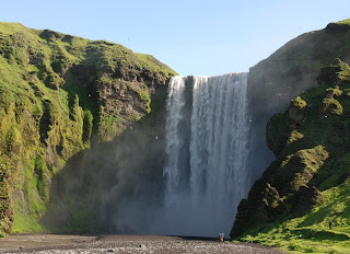
Tuesday morning was bright and sunny and we drove up to Skogarfoss, another stunning waterfall. We continued across fields of black ash, and over a vast lava plain from the 1783 Laki eruption. It is now covered in moss.
Later in the afternoon we drove along the edge of the Vatna Jokull Icecap and there was glacier after glacier, like icing dripping down the side of a cake. In 1996 large sections of the bridges over the lava flows were washed away by large chunks of ice from these glaciers. The last glacier we passed was the Jokulsarion where the ice comes right down to the sea. We stayed near Hofn, #3 on the map.
Wednesday morning was raining again, but we thought we would try our luck with an excursion to Papey Island looking for seals and puffins. As we left Djupivogur the rain stopped. Papey Island is about 2 square km and was a sheep farm until recently and is still privately owned (even the little church). There were plenty of puffins, up close and personal, and as there were only 2 other people on the tour, it was great. Papey Island gets its name from the belief that it was first settled by Irish monks, who fled when the pagan Vikings arrived.
Hallgrimskirkja church in Reykjavik. it is supposed to represent basalt columns. The statue in front is of the Viking Leifur Eriksson, the first European to stumble across America. It was a gift from the USA to celebrate 1000 years of the Icelandic parliament
Sun Voyager sculpture on the Reykjavik foreshore
Thingvellir - the site of the first Alping or assembly in 930 A.D. On the plain below the escarpment is the law rock. It was here that every year, an official read aloud all the laws. It also happens to be on the fault line between the American and European tectonic plates
Strokkur, the very much smaller, but more regular geyser, next to Geysir, the Daddy of them all.
Gullfoss waterfall
Some of the famous Icelandic horses, photographed at 11 at night.
The crater Kerio
Skogarfoss waterfall
One of the glaciers coming down from the Vatnajokull icecap Note the lupins in the foreground - they are exotic but seem to do particularly well.
Icelandic sheep taking it easy
A group of avid photographers at the basalt cliff at Reynishverfi
Ice in the sea where the Jokulsarion glacier comes right down to the sea.
An harbour seal relaxes on rocks near Papey Island
Puffins on the cliff on Papey Island. Puffins make a burrow up to 1.5 m long for their nest, so they are always found at the top of the cliff


How fantastic, Kate!
ReplyDeleteThanks for posting your photos for the benefit of we armchair travellers.
Wow!!! I love the puffins. Continue your happy travels. How cold is it up there? It is weird the time of night and being daylight. Cheers Jenni
ReplyDeleteActually, Sunday night in Amsterdam was the first proper darkness we had had for weeks. The weather was mostly quite mild. One day in Iceland was 22
ReplyDelete