Wednesday, June 30, 2010

Reykjavik, Iceland

Sunday June 20th, 2010

Reykjavik, Iceland

It was 5.15 in the afternoon by the time we returned to the mainland after our excursion to Papey Island. The sun had come out, but there was still mist hanging around some of the hills as we drove around some of the Eastern Fjords. 


One attractive town was Faskrudsfjordur. This used to be a base for French fishermen and the French built a hospital and a chapel there. All the street signs are in both French and Icelandic. The largest town on the largest fjord is Reydarfjordur. It was a large Allied base during World War II, and now it is the site of a large aluminium smelter.

From there we turned north, away from the coast, and drove along a steep river valley to Egilsstadir (#4 on the map).

Thursday morning we took a run out to Seydisfjordur, the terminal for the car ferry from Denmark. The road runs across a high snow covered plain and then steeply winds down into the town. The ferry had just arrived and it was quite a change to meet so much oncoming traffic. I felt sorry for the cyclists just starting their tour of Iceland - quite a strenuous climb, but the scenery is spectacular.

The town itself is in a lovely natural setting at the head of the fjord and surrounded by snow capped mountains. Many of the attractive wooden houses date from the nineteenth century when the herring industry was important.

Our next destination was Saenautasel, a small turf farmhouse which was used as a homestead from 1843 until 1943, except for the period 1875-1880 when ash from the Askja eruption made the area uninhabitable. The area roundabout is a high desolate heath and life would have been a struggle so it is probably not surprising that after the 1875 eruption, many of the farmers fled to America.

The Jokulsargilufur Canyons National Park is near here. As you enter the park, the road sign warns - 48 km of bad gravel and the first few  kilometres were pretty awful horrugations, but it can't have been so bad, because when we got to Dettfoss there were 3 tour buses ( the cause of the corrugations) parked there! Dettfoss waterfall has an enormous volume of water, but it is dirty gray and not very pretty. Further along we came to Asbyrgi, a strange horse shoe canyon and  within its sheltering walls a birch forest thrives - such a contrast to the desolate heath we drove over earlier in the day.

Friday we spent around Lake Myvatn exploring the sputtering mudpots, steaming fumeroles, strange lava formations, craters and pseudo craters and I have included a few photos below. Friday night we stayed in a much larger Edda Hotel in Akureyri - Iceland's second biggest town. (#6 on the map). Edda hotels operate in summer using buildings which function as boarding schools during winter. The town even runs to a pedestrian mall where I bought myself an Icelandic souvenir - a handknitted sweater.

We were glad the supermarket was open and we were able to buy ourselves a low alcohol beer as the day had been surprisingly warm - over 20 C.. Beer was illegal in Iceland until 1989. Apart from low alcohol beer, all alcohol can only be bought in government liquor shops and in some towns the hours are extremely restrictive, e.g. between 5 and 6 p.m. Monday to Friday and between 4 and 6 p.m. on Saturday in Djupivogur!

On Saturday we had a long drive back to Reykjavik, but still made three stops. the first was to a horse farm where my niece had helped with the autumn muster about 5 years ago. Evelyn welcomed us and showed us some of her 150 horses.

Iceland, like Australia has very strict quarantine rules. If a horse is sent abroad, it can never return to Iceland. Just recently there has been an outbreak of what maybe equine flu and the owners and breeders were very worried. The big biennial horse show was cancelled. The suspicion is that the virus arrived on equipment from the USA.

Our next stop was at the stone church at Thingeyrar. This church was built between 1864 and 1877, but there has been a church and/or Benedictine monastery on the site since at least 1112. It took five years to haul the stone to the site, by dragging it across the ice in winter and then several more years to import the lime mortar from Denmark. The ceiling has 1000 gold stars painted on it.

Last stop was the excellent  Settlement museum in Borganes. The English audio guide explains a lot about the original Viking settlement. Models of the longboats show how the livestock and people were transported on the 3 or 4 day voyage.

It is estimated that by the time the first parliament was held in 930 A.D. (I should say C.E. as the Icelandic parliament did not vote to become Christian until 1000 A.D.) there would have been a population of more than 30,000.

We returned a very dusty car to Hertz at 6 p.m. which meant we avoided the necessity of finding a parking place - not easy in central Reykjavik!

On Sunday we began the long trek home, via Amsterdam, Dubai and Kuala Lumpur. 


I could not resist another puffin photo.

Our boat at the landing on Papey Island. The puffins nest along the top of the cliff near the landing.
Moss campion on Papey Island
The little private church on Papey Island.
Typical late afternoon along the Eastern Fjords
Seydisfjordur, where the Danish car ferry docks.
One of the Norwegian style 19th C houses in Seydisfjordur.
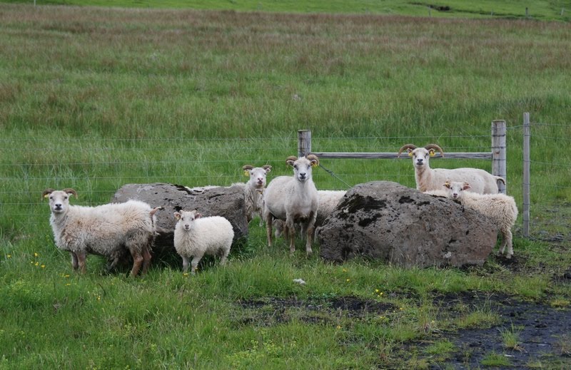
Pastoral scene.
Driftwood gable end of a turfhouse at Laufas
Early 20th C kitchen utensils in the turf house at Laufas
I was intrigued by the small beds in the turf houses. This cot could be expanded lengthwise.
and the width of this bed could be expanded.
Pseudo craters at Skutustadargigar
Another lava field and lake in the Lake Myvatn area.
Lunar landscape near Lake Myvatn
Mud pot gurgling - a bit hard to catch on camera!
Myvatn Geothermal Baths. Swimming is very popular in Iceland. Apart from natural hot springs, the abundance of geothermal heat is used to provide public swimming pools and saunas, spas in most towns.
The midges are thick around Lake Myvatn. They do not bite and although annoying are not as irritating as Australian bush flies, so the head nets looked overkill!
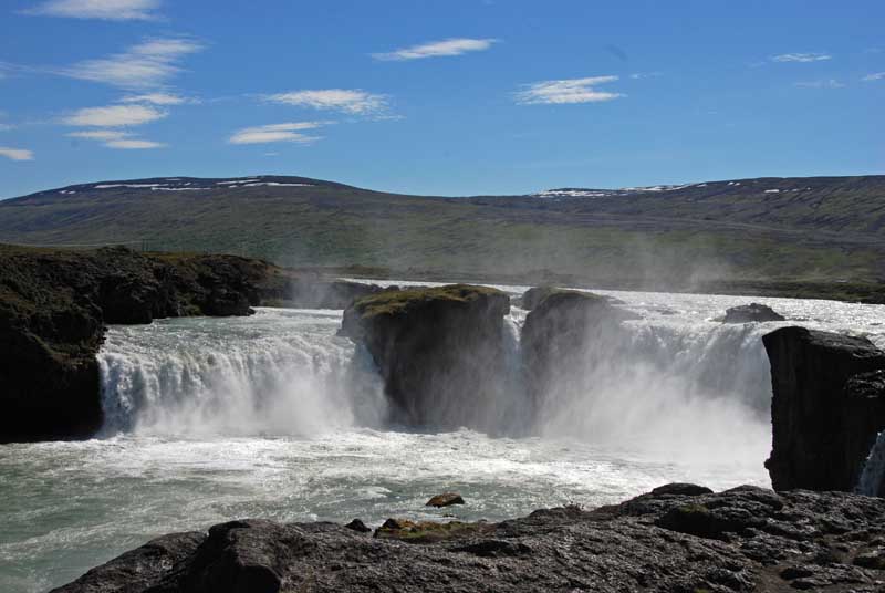
Godfoss - waterfall of the Gods
A 14th C alabaster altarpiece in the Thingeyrar church. This was made in Nottingham. I am always fascinated by the extent of trade in Medieval and earlier times.
One of Evelyn's Icelandic horses
Whooper swans breed in Iceland
This street sculpture in Reykjavik appealed to me.
Both menus are about A$55 so I don't think they will be big sellers.

I have tried to record our holiday in an interesting and informative way and hope you have enjoyed reading it. This blog is now going into hibernation, but hopefully in a few months we will be able to make another trip somewhere and I will reactivate it.

Sunday, June 20, 2010

Akureyri, Iceland

Thursday, June 17th, 2010

The numbers on the map refer to our overnight stops
1 and 7 - Reyakjavik
2 Skogar near Vik
3 Hofn
4 Eidar near Eglisstadir
5 Laugar, not far from Lake Myvatn
6 Akureyri

Last Sunday we flew from Bergen to Reykjavik. The airport is about 50 km from Reykjavik - time for one of our fellow passengers on the shuttle bus to wipe himself out with Finnish vodka. The driver managed eventually to wake him up and put him off the bus at his stop. The driver then mopped up the spilt vodka before we continued.

We stayed in Central Reykjavik at the 101 Guesthouse which occupies the third floor. Above it on the 4th floor is the appropriately named "4th floor hotel" - both run by Chinese.

I don't think you would come to Reykjavik to study the architecture, however we walked around and found a few interesting old buildings. Corrugated iron is a common building material.

On Monday morning we picked up our Toyota Avensis from Hertz and set off following our suggested itinerary, which led us more or less around Iceland on the Ring road in an anti clockwise direction.

We had not gone very far, before we left the traffic behind and we drove into a town looking for a bank. There were two large ones, a supermarket, petrol station and not much else.

Our first stop was Thingvellir (Actually th is an approximation of the Icelandic letter. Their alphabet has some extra letters which were dropped from English and German centuries ago!) National Park famous for being where the first Icelandic Parliament was held in 930 A.D. It was later moved as it is a very active geological area being on the fault line between the American and European tectonic plates and the cracks and fissures are clearly visible.

That same day we visited Geysir, the original geyser and Gullfoss, a pretty spectacular waterfall.  Next stop was Kerio crater, but by then it had started to rain and it just got more and more bedraggled.

We saw nothing of Mt Hecla or Eyjafjallajokull glacier and volcano (the one which caused all the recent problems) although we drove over the recently repaired sections of road. As it is the only road, repairs are urgent. It was quite atmospheric driving past the barely visible nearby hills and no wonder Icelanders believe in the hidden people and other supernatural phenomena. We stayed near Vik, #2 on the map.

Tuesday morning was bright and sunny and we drove up to Skogarfoss, another stunning waterfall. We continued across fields of black ash, and over a vast lava plain from the 1783 Laki eruption. It is now covered in moss.

Later in the afternoon we drove along the edge of the Vatna Jokull Icecap and there was glacier after glacier, like icing dripping down the side of a cake. In 1996 large sections of the bridges over the lava flows were washed away by large chunks of ice from these glaciers. The last glacier we passed was the Jokulsarion where the ice comes right down to the sea. We stayed near Hofn, #3 on the map.

Wednesday morning was raining again, but we thought we would try our luck with an excursion to Papey Island looking for seals and puffins. As we left Djupivogur the rain stopped. Papey Island is about 2 square km and was a sheep farm until recently and is still privately owned (even the little church). There were plenty of puffins, up close and personal, and as there were only 2 other people on the tour, it was great. Papey Island gets its name from the belief that it was first settled by Irish monks, who fled when the pagan Vikings arrived.


Hallgrimskirkja church in Reykjavik. it is supposed to represent basalt columns. The statue in front is of the Viking Leifur Eriksson, the first European to stumble across America. It was a gift from the USA to celebrate 1000 years of the Icelandic parliament
Sun Voyager sculpture on the Reykjavik foreshore
Thingvellir - the site of the first Alping or assembly in 930 A.D. On the plain below the escarpment is the law rock. It was here that every year, an official read aloud all the laws.  It also happens to be on the fault line between the American and European tectonic plates
Strokkur, the very much smaller, but more regular geyser, next to Geysir, the Daddy of them all.
Gullfoss waterfall
Some of the famous Icelandic horses, photographed at 11 at night.
The crater Kerio
Skogarfoss waterfall

One of the glaciers coming down from the Vatnajokull icecap Note the lupins in the foreground - they are exotic but seem to do particularly well.
On
Icelandic sheep taking it easy
A group of avid photographers at the basalt cliff at Reynishverfi
Ice in the sea where the Jokulsarion glacier comes right down to the sea.
An harbour seal relaxes on rocks near Papey Island
Puffins on the cliff on Papey Island. Puffins make a burrow up to 1.5 m long for their nest, so they are always found at the top of the cliff

Sunday, June 13, 2010

Bergen, Norway

Bergen, Saturday June 12th

Firstly, here are a few more photos of Finland.

Reindeer tend to run away!
The white lichen is preferred reindeer tucker
Boats on Lake Inari
Sami hand knitted mittens for sale
Here is a map showing our ports of call


Last Monday, a minibus picked a Swiss couple and ourselves in Inari and drove us to Kirkenes. It was still cold and inclined to rain, but visibility was good. We were driving through birch and pine. The trees are not huge, but may have taken two hundred years to grow to that size. We saw several groups of reindeer, including some calves, and the driver stopped for photos. All the reindeer belong to someone and are identified by ear marks. When the mosquitoes are at their most vicious, the reindeer go up onto the open fells in an effort to escape them. The Sami are then able to lasso the calves and mark them with the same tag as their mothers.

As we drove North, the trees became more stunted and the pines disappeared altogether.

Most of the people living in this area are Sami, and the schools are taught in one of the Sami languages. One school has only 9 pupils and 4 teachers. Also as the Sami prefer to live in a fairly isolated way rather than in villages, there is a school taxi service!

By the time we crossed into Norway, there were no trees at all. Although there was a joint Finnish Norwegian border post we did not stop. It is a road with little traffic and few settlements but there is a supermarket on the Finnish side, as Finland is much cheaper than Norway.

In Kirkenes, the Kong Harald was already in Port and we boarded straightaway.

Overnight on the way to Hammerfest there was a bit of a swell and some people did not make it to dinner.

Hammerfest has a population of about 7000 and is at about 71 degrees North. In the southern hemisphere, this is the same as Cape Adair in Antarctica,and noone attempts to live there. The difference is Hammerfest has the magic Gulf Stream which makes an incredible difference.

Hammerfest and all the other Northern settlements as far south as Tromso, were razed by the retreating Nazis in 1944.

As we sailed south we usually called into 3 or 4 ports each day. Sometimes we stopped for only 15 or 30 minutes, but other times we stayed 2 or more hours. At each port, passengers got on and off and forklifts scurried around loading and unloading pallets of cargo. At one place we picked up a huge number of pallets of fish, then elsewhere it was peat potting mix and fertilizer, to say nothing of the odd lounge suite. In most places we had a short walk around town. In Stokmarknes we visited a fascinating museum about the history of the coastal ferry and nearly got left behind.

When we crossed the Arctic Circle south of Bodo, we were given Cod Liver Oil and Aquavit. It might be good for you, but I think I can manage without it.

I will mostly let the photos illustrate how the scenery changed as we came South and the weather improved.

Hammerfest
In Hammerfest I am not surprised people want to add some colour!
Plenty of snow and not much vegetation near Hammerfest

As we came south Tromso was the first town we saw any buildings older than about 1950.
Tromso at midnight
Trollfjord
Cod drying racks at Svolvaer
 
Shipboard life.
Torghatten mountain - south of Trondheim. The hole is 160m long, 35m high and 20m wide.
Trondheim
Gamle bridge in Trondheim
Stave church at Kvaernes (near Molde)
One of the bridges on the Atlantic Road (near Molde). Sometimes in winter storms, the waves break across the road and it has to be closed.
The narrow Steinsundet Sound near Bergen
Laburnum and lilac in Bergen.
Waterfront of the Bryggen area in Bergen
One of the alleys in the Bryggen area. This area has looked like this since the 12th century. It was burnt several times, but always rebuilt to the same plan, the last time in 1702. All restoration is done using seasoned mature pine (from 150 to 200 year old trees) and only traditional tools are used.